Executive Summary
1. Kalpasar Project – An Overview
The shortage of fresh water reserves is a now a world-wide problem and it is estimated that about 57% of the world population would be confronted with water-shortage by 2050. Aquifers, which provide water for one-third of the world's population, are used out before nature can complement them. Water scarcity is already a focus of attention all over the world including India. Gujarat, located on the western coast of India, is one of the high growth and industrialised states in the country. However, Gujarat is also a water-deficient state that has been able to develop only 60% of its available surface water resource, because no suitable inland site is available for the storage of the remaining 40% of surface water.
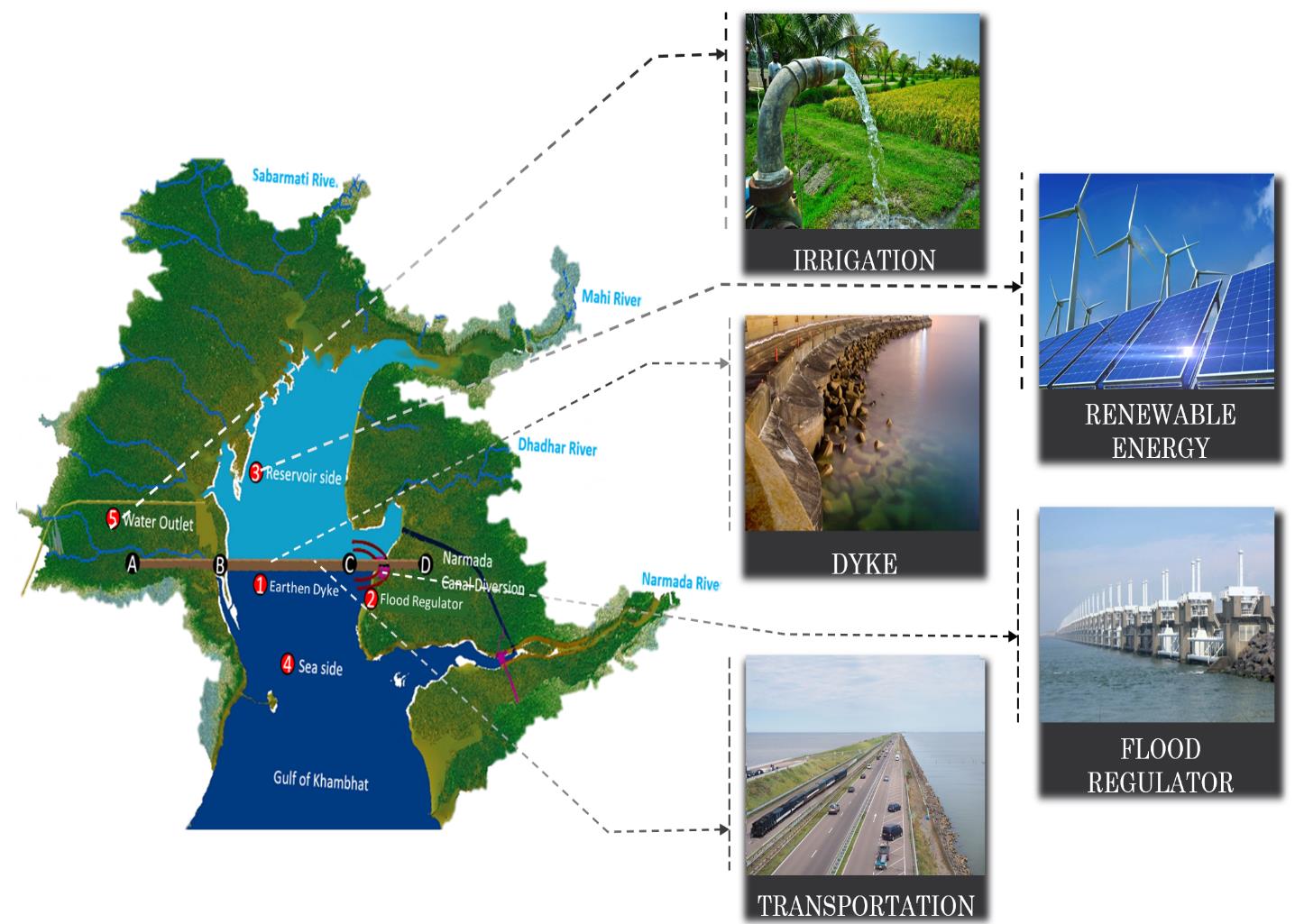
The Kalpasar Project is envisaged to be a multi-purpose project involving construction of 60.13 km long earthen dyke with a 2,010 m long concrete flood regulator, across the Gulf of Khambhat from Bhavnagar town on the west to Dahej town on the east in the state of Gujarat. This would create a large coastal freshwater reservoir by storing the run-off of 7807 Mm³ of water from rivers Sabarmati, Mahi, Dhadhar rivers and the east-flowing Narmada River.
In a bid to harness the large volume of huge freshwater from rivers Sabarmati, Mahi, Dhadhar, Narmada, and Saurashtra which flow into the Gulf, the Government of Gujarat (GoG) proposed the Gulf of Khambhat Development Project, popularly known as Kalpasar Project, to meet the freshwater demands for drinking and irrigation especially in the Saurashtra region.
Though the idea of a dyke across the Gulf of Khambhat was seeded in early 1960s, the project in its present form and features has evolved through the interplay of ideas and concepts which have been concretized through several technical studies carried out by various premier national and international institutes. The investigations were initiated with a Reconnaissance Study (1989) by the Royal Haskoning DHV of the Netherlands, and later a Prefeasibility Study (1998) by Haskoning DHV. A detailed study was carried out by a team of national and international experts and a comprehensive report titled Six Specific Studies (1999) was submitted to the GoG. In 2015, the National Institute of Ocean Technology (NIOT), Chennai, completed seabed investigations, such as bathymetric surveys, geophysical related studies. These other studies carried out for their project include geophysical and geotechnical studies along the dyke corridor, bathymetry surveys, numerical model studies to assess the impact of the dyke on water levels, currents & sedimentation, dyke break, dyke construction, reservoir stratification, storm surge and socio-economic studies etc.
As the project moved to the next phase and in view of the multi-disciplinary expertise available in the Ministry of Earth Sciences (MoES), the Kalpasar Department (GoG) requested Ministry of Earth Sciences (MoES) to prepare a Detailed Project Report (DPR) for the Kalpasar Project and MoES agreed to take up the work through National Centre for Coastal Research (NCCR), an attached office of the Ministry and NCCR took up the challenge and prepared the DPR on behalf of MoES. Now the technological and scientific understanding of the Kalpasar project has matured to the next phase wherein, the Ministry of Earth Sciences (MoES), Government of India has developed of the Detailed Project Report (DPR) for the Kalpasar Project thereby moving towards realizing the vision for the prestigious, multipurpose and world's largest freshwater lake in marine environment.
As a multi-purpose project, the Detailed Project Report of Kalpasar Project, involves the following components:
- Design for 60.13 km long dyke across the Gulf of Khambhat connecting Bhavnagar and Paniyadra village (Bharuch);
- Design for a Flood regulator of length 2.01 km with a maximum outflow capacity of 1,10,000 cumecs;
- Design of Hydromechanical gates including 50 m spanning Service Gates and Maintenance Gates to discharge water from Reservoir side to Sea Side;
- Construction Sequence in gulf region including the sudden closure of dyke for a length of 20 km with caissons and horizontal closure of length 10 km;
- Multi-Mode Transportation Corridor, comprising of 16 lane Roadway with Intelligent Transportation Systems (ITS) and 4 lane Railway on the Dyke, to connect and reduce the travel distance between the East and West banks of the Gulf;
- Renewable Energy Design for generation of 2,500 MW;
- Instrumentation and Monitoring Design for the dyke; and
- Social-Economic Impact Assessment
1.1 Uniqueness of Kalpasar Project in comparison with Similar Projects
Saemangeum Tideland Project, South Korea
The Saemangeum Seawall is a man-made dyke in South Korea and it remains the country's largest-ever development project. The Government of South Korea mooted the project in the 1970s and commenced it in 1991 but construction finalized in 2010 after several challenges. Saemangeum Seawall is 33 km long that encloses 160 square miles of seawater. South Korea's plan was to construct a dyke to link a total of three headlands located in the south of Gunsan, the country's industrial coastal city located 168 miles from Seoul.

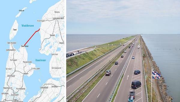
Afsluitdijk Dyke, Netherlands
The Afsluitdijk in Netherlands, was constructed between 1927 and 1932 and runs from Den Oever in North Holland province to the village of Zurich in Friesland province, over a length of 32 km and a width of 90 m (300 ft), at an initial height of 6.7 m (22 ft) along the section at Friesland. It also connects the North and West of the Netherlands, through which 20,000 vehicles drive every day.
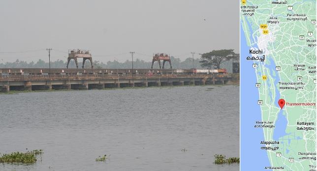
Thanneermukkam Bund, India
The Thanneermukkam Bund was constructed as a part of the Kuttanad Development Scheme to prevent tidal action and intrusion of salt water into the Kuttanad low-lands across Vembanad Lake between Thannermukkom on west and Vechur on east. It has been built across Lake Vembanad and is functional since 1976. It is the largest mud regulator in India. This barrier essentially divides the lake into two parts — one with brackish water perennially and the other half with fresh water fed by the rivers draining into the lake.