4. Engineering Investigations
The Comprehensive Engineering Investigations carried out for the design and construction of the proposed Kalpasar Project were examined. Topography surveys around the project site were carried out to understand the terrain elevations. Detailed Bathymetry surveys to assess sea floor variations and oceanographic measurements such as tides and currents were observed for entire Gulf of Khambhat. The geological, geophysical and geotechnical characteristics of the substrate of the sea bed underneath the dyke corridor was investigated in detail. The investigations include Multi beam echo sound survey, Side scan sonar survey, Sub bottom profiler survey, Sparker / Boomer survey down to a depth of 90 m, Sub-scan survey (velocity) as it nears the bottom. Detailed observations on surface temperature, rainfall distribution in the meteorological subdivision adjoining the Gulf of Khambhat carried out for analyzing the changes in regional climate. Detailed investigations on hydrological and hydro-geological features of catchment area of Kalpasar reservoir was studied to arrive at water availability for the Sabarmati, Mahi, Dhadhar and east flowing rivers of Saurashtra draining into Gulf of Khambhat. Detailed analysis of water allocated for providing irrigation to agricultural area in the Saurashtra region along with existing and proposed cropping pattern was investigated.
4.1 Physical Oceanography
The GoK has a width of 80 km at the mouth and funnels down to 25 km over a longitudinal reach of 140 km. In the north Indian Ocean, the maximum tidal range of more than 10 m is found in GoK, which is the second maximum over the globe after Bay of Fundy, Canada. The shape, varying bottom friction coefficients, and the large width of the continental shelf of the central west coast of India were the main agents behind the tidal amplification of the Gulf. The tide here is of mixed semi-diurnal type with diurnal disparity and variable amplitudes, which increase from the south to north along GoK. The maximum current speed of 3.3 m/s was recorded in GoK and current flows towards north-northwest and south-southwest during flood and ebb respectively. The tidal currents of GoK have several small-scale distinct features due to the complex topography and varying tidal amplitude. The principal factors, which regulate the seasonal variability of GoK, are the Arabian Sea at the Gulf's entrance and the Indian monsoon. The major rivers which drain into the Gulf are Narmada, Tapi, Mahi, and Sabarmati. The monsoonal freshwater discharges of these rivers are immense and the maximum contribution is from river Narmada, ranging between 10,000 and 60,000 m³/s during monsoonal floods.
The Gulf is exposed to seasonally reversing wind with winds veering from the southwest (SW) during the summer monsoon (June – September) and from the northeast (NE) during the winter monsoon period (October – January). The period between the winter and summer monsoon is the pre-monsoon period (February – May). Higher wind speeds of up to 21 m/s are likely to occur during the SW monsoon. The Gulf is expected to be influenced by large-scale wind-driven circulation. The jet currents in the proximity of the 60 m depth contour are considered to be the coastal ocean boundary, and do not allow the gulf-water to be adverted / flushed out into the open sea directly. The Gulf is homogeneous and displays a one-layer structure, and currents at deeper depths inside the Gulf follow the same velocity pattern as the surface due to the shallowness of the depths and the high tidal amplitudes.
The waves in the northern Arabian Sea largely depend on the winds blowing over the Indian Ocean and Arabian Sea. Waves along the west coast of India are high during the summer monsoon. Also, waves are generated by low atmospheric pressure (storm surges) and displacement of the ocean floor, in particular by earthquakes (tsunami). Along the Gulf of Khambhat, the arrival time of the tsunami wave is seen to be faster with high resolution bathymetry data. It is important to note that for the modelled tsunamigenic earthquakes with 8.8 magnitudes (Mw), the water level height along the proposed Dyke axis ranged between 0.37 m and 0.48 m. Further, the forces due to tsunami waves reveal that tsunami would not pose any threat to the proposed Dyke.
Seiches, as natural resonant oscillations, are generated by a wide variety of mechanisms; including tsunamis, seismic ground waves, internal ocean waves, and jet like currents. A high resolution hydrodynamic numerical model (MIKE 21 HD FM) has been set up to study seiches for the GoK including Kalpasar Lake region. The seiches amplitude in the basin is ranging from 14 cm to 70 cm using GEBCO while it is ranging from 22 cm to 5 cm using NIOT data. The maximum seiches for the hypothetical cyclone track through the Gulf of Khambhat occurring close to the Dyke at extraction point 3 from both data. The seiches current speed varies from 6.5 cm/s to 34 cm/s in GEBCO depth and it vary from 8 cm/s to 70.1 cm/s in NIOT depths.
In essence, the Kalpasar Dyke's successful design hinges on the integration of these oceanographic parameters. Each factor contributes to creating a huge freshwater reservoir to address water scarcity, fostering agricultural growth through irrigation, improving connectivity with a road and rail network, reclaiming 1,00,000 hectares of land for development, boosting fisheries resources conserving the environment, enhancing economic growth, and reinforcing climate resilience. This comprehensive approach contributes to Sustainable Development Goals (SDGs), economic progress, and improved livelihoods while addressing pressing water, energy, and infrastructure challenges.
4.2 Geotechnical Investigations
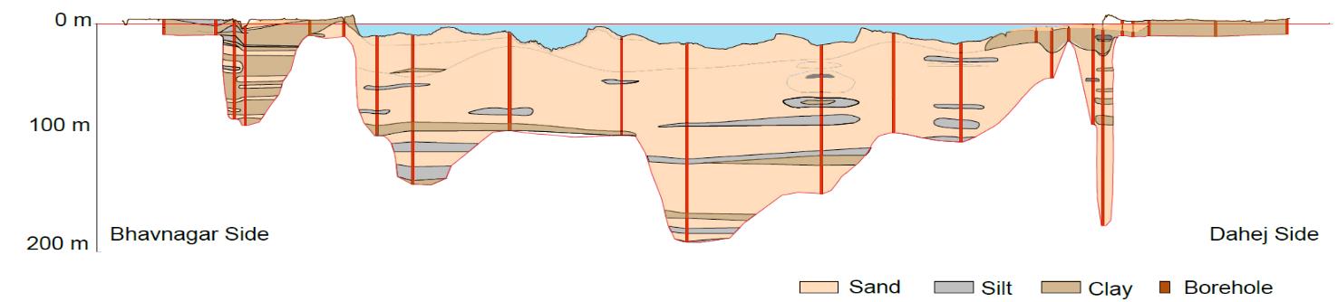
Boreholes were carried at 41 locations and CPT was carried out at 8 locations for the design of the Kalpasar dyke. The depth of investigation varied from 15 m to 200 m. Standard Penetration Test (SPT), Cone Penetration Tests (CPT) with pore pressure measurement, In-Situ Vane Shear Test, In-Situ P-S Suspension Logging and In-Situ Permeability were carried out to provide data on the in-situ soil conditions. Based on the results and the soil profile in the region, the entire geotechnical profile can be split into three sectors. The type of soil identified is almost similar in the classified sectors and is described in detail. The sectors are,
Sector 1: Intertidal region on the western side of the dyke profile close to Bhavnagar
Sector 2: Intermediate region between the two intertidal regions where the main dyke is to be constructed
Sector 3: Intertidal Region on the Eastern side of the dyke profile close to Dahej