6. Environmental Impact Assessment
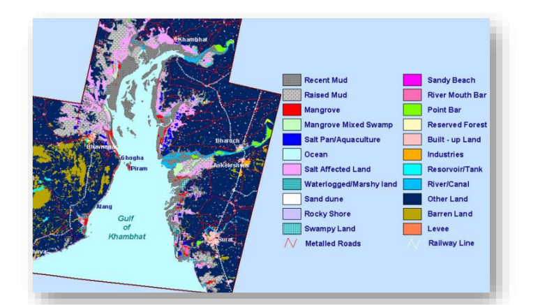
To make a relevant and reliable assessment of project impacts, the baseline situation on the environment is to be collected. The baseline assessment includes data on the relevant environmental characteristics of the study area, as well as information on any changes anticipated before the proposed project commences. In this connection there is a need to understand the past mangrove cover in the area to bring out the relation between the present mangrove status before predicting what the future conditions would be due to the construction of the Kalpasar dyke. Intensive survey of the mangrove vegetation was carried out to assess the species composition, density, and distribution pattern at some prefixed sites in the intertidal belts of the Gulf of Khambhat and the adjacent estuarine environment. The assessment was done during low tide at each 25 km² grid within the buffer area of the Project Sites.
Further an attempt is made to understand the possible changes that will take place in the mangrove ecosystem after construction of Kalpasar project. For the purpose of prediction of the likely changes occurring as the system changes from marine to brackish to fresh water, data on present distribution of species in the three habitat classes, viz. marine, brackish and freshwater was used and the species which are likely to be vulnerable were identified and suitable mitigation strategies have also been evolved. Mudflats available near Bhavnagar, Aliabet Island, Bhavnagar port, Surat, Valsad will be used for the rehabilitation of mangroves. Mud flats in the Anand district are mainly developed due to the silting from Dhadhar and Narmada. The mud flats area is estimated to be approx. 12,799 ha. of which 3,407 ha. area covered with halophyte vegetation.
The salt pans in the area of Gandhar, Paniyadra, Jambusar and Khambhat will likely be affected because of dyke construction. There is no immediate threat of submergence to any of the Saltpans due to the proposed Kalpasar reservoir till the completion of the construction.
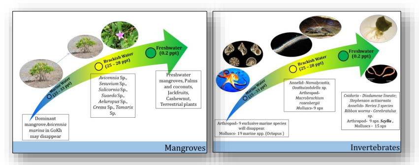
The vast intertidal area of Gulf of Khambhat sustains good population of mollusses and the fishery thriving in the area. The primary survey was undertaken for various groups both in the terrestrial and marine system. The group-wise representation of the fauna in the study area indicated that the fishes and mollusses are the dominant groups. A total of 191 species were reported from the study area spread in five different habitats, namely, coastal area, riverines, coastal wetlands, scrubland and agriculture. Among the various habitats, herbs are the dominating feature of the landscape with representation from 62 families. As the system changes from marine to freshwater, the species belonging to pure marine will be relocated and, in the beginning, opportunistic species will take over. Generally, these species represent the estuarine species, and depending on the water quality status, other species in the freshwater regimes will occupy the areas of the estuarine habitat. This will hold more relevance for the phytoplankton, zooplankton and benthos.